Solutions For Good
We develop tailored geospatial applications that solve specific problems within communities. These apps are designed to be user-friendly and accessible, ensuring that community members can easily use them to address local challenges. By incorporating features such as real-time data collection, mapping, and visualization, our applications enable users to gain valuable insights and take effective action.
Our solutions empower communities by equipping them with the knowledge and skills needed to utilize geospatial technology. We work closely with local organizations and community members to ensure that our applications meet their unique needs and objectives. Through training sessions and workshops, we teach users how to effectively leverage these tools to advocate for change and improve their quality of life.
Emergency Management
2025 Palisades Fire Damage Evaluation
This dashboard highlights the structural impact of the Palisades Wildfire, which occurred in January 2025 in Los Angeles County, California. The dashboard visualizes critical parcel-level and building-level data statistics showing the large scale impact of this event. This project exemplifies how GIS can be used for environmental monitoring, emergency response and long-term recovery.
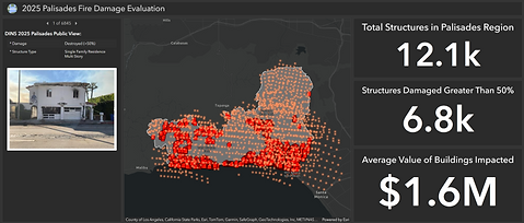
This map showcases all the structures, structures damaged greater than 50% and the average value of the buildings impacted in the Palisades Wildfire in Los Angeles, California

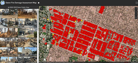
This map showcases all the structures, structures damaged greater than 50% and the average value of the buildings impacted in the Eaton Wildfire in Los Angeles, California
2025 Eaton Fire Damage Evaluation
This dashboard highlights the structural impact of the Eaton Wildfire, which occurred in January 2025 in Los Angeles County, California. The dashboard visualizes critical parcel-level and building-level data statistics showing the large scale impact of this event. This project exemplifies how GIS can be used for environmental monitoring, emergency response and long-term recovery.
Mapping the Damage of the Eaton Fire in Los Angeles
This map showcases the damage assessment reports from the 2025 Eaton Wildfire in Los Angeles, California. This application is a visual representation of the damage created by the fire in the Eaton community. The goal of this application is to use GIS as a tool to illustrate the tragedy of the wildfires in Los Angeles and stand in solidarity with Angelinos during this tragic time.
This map showcases the damage assessment reports from the 2025 Eaton Wildfire in Los Angeles, California.

This map showcases the damage assessments reports and images from the 2025 Palisades Wildfire in Los Angeles, California.
2025 Los Angeles County Wildfires
This application showcases the impact and damage in the Eaton and Palisades communities after the 2025 Los Angeles Wildfires. This application provides a recap on the amount of impact based upon NASA fire data, parcel and building information in the affected areas.
Mapping the Damage of the Palisades Fire in Los Angeles
This map showcases the damage assessments reports and images from the 2025 Palisades Wildfire in Los Angeles, California. This application allows users to learn more about their surroundings and visualize the damage of wildfires in the community. This application is used as a tool to promote change and stand in solidarity with Angelinos during this tragic time.
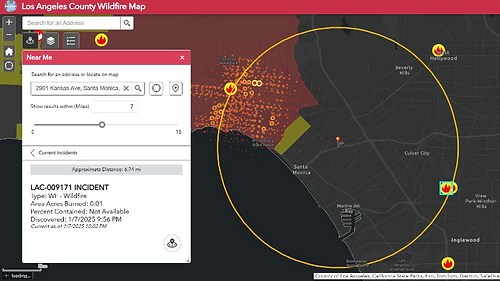
This application showcases the impact and damage in the Eaton and Palisades communities after the 2025 Los Angeles Wildfires.
Violence Reduction & Community Safety
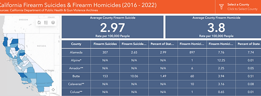
Mapping Firearm Suicides in California
In the most recent custom dashboard, RomoGIS along with Hope and Heal Fund created a map outlining the reported firearm homicides and firearm suicides in the State of California. This custom application highlights firearm related deaths from 2016 to 2022 and helps shed light on the impact of firearm deaths in California.
A series of web applications documenting firearm suicides and homicides in the state of California.

A series of web applications documenting firearm homicides in the state of California.
Mapping Gun Violence in California
In an initial collaboration with Hope and Heal Fund, RomoGIS created a custom and accessible application that allowed users to interact with a map outlining the reported firearm homicides in the State of California. This application provides community leaders with a helpful tool that highlights firearm related homicides from 2014 to 2022. This custom application can be used to strengthen advocacy efforts that prevent further firearm related violence in California.
Public Health
Health Equity for Black Communities in Contra Costa County
RomoGIS partnered with Ceres Research to map health access for black residents in Contra Costa County. This baseline data was then used to identify the most ideal locations for public health interventions such as mobile healthcare units.

This application was used by Contra Costa County to identify the best locations for mobile healthcare units.
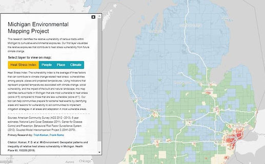
MI-Environment Web Application measuring heat stress in the state of Michigan.
MI-Environment Publication and Research Tool
The MI-Environment project was a collaboration between researchers at the University of Michigan School of Public Health, including Dr. Trish Koman and RomoGIS. The project aimed to investigate geospatial patterns of heat stress vulnerability across Michigan and identify communities most at risk for heat stress. By creating this tool, we hoped to inform interventions to mitigate the impact of extreme heat events and direct resources to the populations at most risk of experiencing heat related impacts. Through this project, we aimed to shed light on the unequal distribution of heat stress vulnerability within Michigan communities and highlight the need for targeted interventions to address this issue.